|
|
Explore
Are you brave enough to ride the Spooky Express at the Waterford & Suir Valley Railway? |
|
|
Auto
Services | Beauty | Bridal
Salons | Building Services
| Diving Holidays
| Engineering
| Equestrian | Estate
Agents | Events | Fairs
& Shows | Farmers Markets | Fishing
| Florists
| Fuels | Guest
Houses | Hardware | Haulage
| Hostels | Hotels
| Insurance |
Lingerie | Jewelers
| Mens Wear | Museums
| Music Sessions |
Pet Services | Photographers | Self
Catering | Taxi | Travel
Agents | Wedding Transport
|
| Slideshow
of Lismore castle garden. |
|||||||
Only a seventh of its working people are employed in agriculture. The land is fertile, and farms are amongst the largest in Ireland, averaging 30 hectares. Dairying and cattle production are the two leading types of farming. About one sixth of the land is under arable crops, these are mainly feeding barley, potatoes, sugar beet, and wheat. As is the norm in the rest of the country sheep are reared on the higher ground. Manufacturing is very important, it accounts for about 30% of employment. The county is famous for the manufacture of the crystal which bears its name, waterford crystal is exported across the world and employs about 2,000 people. Half the population work in various service industries. The most important service industry is retail and wholesale distribution. Others include Tourism, catering, education, finance, health, public administration, and transport,. There is a regional technical college city. Tramore, which has a fine beach and recreation facilities, is one of the major Irish seaside resorts. Dunmore East is one of the major fishing ports in Ireland and has fish-processing industries. There has been much development of forestry in the upland areas of the county. Waterford city is the center for transport, from which railways and major roads radiate to Wexford, Dublin, and Limerick. But these do not pass through the rest of the county, and the only national primary road is the N25 from waterford to Cork. Lying on the deep and sheltered waterford Harbour and Suir estuary, waterford city is one of the major seaports of the Irish Republic. It is particularly important for container traffic but has no passenger services, the county has a small airport. The annual rainfall is 100 centimetres. Being in the southeast, the coastal lowlands have fewer wet days and more sunshine than most of Ireland. The average monthly temperatures are 6 °C in January and 16 °C in July.
|
|||||||
|
|
|
|||||||
|
|
Google
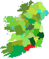
Map of County Waterford. |
||
|
|
||
|
|
|
Beauty
| Bridal |
Eat Out | Equestrian
| Estate Agents | Events
| Fishing | Florists
| Guest | Hotels
| Jewelers
Museums | Music | Photographers | Self Catering | Taxi | Travel Agents | Wedding Transport |


 is one of the six counties in the province of Munster. It
is a coastal county in the southeast of the country. The name
waterford is derived from the Danish Vadrefjord (the sea inlet
of the god Vadre or Odin), the Irish name is Port Lairge,
the county has an area of 1,838 sq. Km. The Atlantic Ocean
forms the county's southern boundary. Wexford lies to the
east, Kilkenny and Limerick to the north, and Kerry to the
west. The greatest distances from east to west are 80 kilometers,
and 40 kilometers from north to south. The largest towns are
Waterford, Dungarvan, Tramore, Portlaw, Lismore and Dunmore
East.
 , and
slate. The west of the county is mainly sandstone, while the valley
which runs from Dungarvan, between the
  Knockmealdowns
to the north and the Drum Hills to the south, lies on limestone.
The River Blackwater enters the county from the west along this
valley but turns south at Cappoquin. It is joined by the River Bride
before discharging into Youghal Bay.